This section took me past Conkers outdoor activity centre, an 11th-century spring, and a herd of alpacas. I entered Leicestershire several times, and promptly left again. Although the weather forecast threatened a soaking, I escaped with only a few light showers.
Walk One
I parked by the village hall in Overseal. It boasts some top-notch public toilets next door, although I was confused by the sign on them. Who plays golf in a public convenience?
Setting off down the road, I passed the village school, with an old winding wheel outside. A right hand turn took me along a cycle path which led to Conkers. This area used to be a coal mine and railway tracks. It has been enthusiastically re-greened, with the obligatory sculptures, nature trails, and historical signage. The effect veers slightly towards nature-as-commodity; there's a sense of smugness that we, as humans, can destroy a landscape utterly and then put it back together again. Then again, it undoubtedly is better than just leaving a huge hole and some rusty iron. And the entire National Forest is a larger-scale attempt to do the same thing, really, by planting trees.
 |
| Overseal school |
 |
| Wildflowers near Conkers |
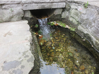
On the plus side, all those gravel cycle paths made for very easy walking. I crossed the Ashby Canal, plodded along a busy road, then followed a bridlepath to Boothorpe and Blackfordby. Blackfordby was the village with the mediaeval spring. It looked very clear and refreshing. I dipped my hands in and sat by it for a few minutes.
At this point I left the NFW to loop back to Overseal. I was intrigued by the Albert Village war memorial, which reminded me, somehow, of a Tesco store. The village inhabitants must have been Princess Diana fans, too. I don't think I've ever seen a Diana Princess of Wales Memorial Woodland before, and it seemed a rather incongruous place to have one.
 |
| Stanley Village war memorial |
 |
| Sculpture in Diana's memorial woodland |
Gresley Woods was beautiful. I could have happily explored it further if my feet weren't starting to hurt. Reluctantly, I left the woods to join a long boring cycle path alongside a railway, and then back along a road to my car.
 |
| Look at those trees! |
Walk Two
My mum joined me for this one. In theory it was shorter than the last walk, but a non-existent footpath and some excessively overgrown vegetation meant that it took us a similar amount of time.
We set off from Hartshorne and immediately had to hack our way through a jungle of field beans. When we got to the wood at the corner of the field, my map showed two footpaths, but the one we wanted was decidedly not there. Fortunately the other one went in much the same direction. It pottered along quite happily to the edge of a housing estate, at which point it went rogue and vanished under six-foot-high weeds. We donned waterproofs and plunged in, eventually emerging triumphant at a stile.
After that we were quite happy to be on tarmac for a short stretch into Blackfordby. Once we'd rejoined the NFW the path became tame and docile once more. It took us past fields of horses and alpacas and into the village of Smisby.
For some reason I'd assumed that Bluebell Nursery and Arboretum, just outside Smisby, had a cafe. We were both ready for a drink and a snack by that point. Sadly it didn't. We had to make do with water and a cereal bar outside St James' church.
Thus fortified, we continued across some fairly uninteresting fields towards Hartshorne. Somebody had hung two pairs of socks on a stile. Just before reaching Hartshorne, we crossed a new section of National Forest. The trees had been planted, but so far were mostly dwarfed by the long grass surrounding them. That took us to the end of Stage 7 of the National Forest Way - six out of twelve stages completed!


Comments