
Springtime walks: Croxden Abbey and Shining Cliff Woods

It seems to be taking a long time to get properly warm, this spring. But suddenly there are flowers everywhere and the world has turned green. We had to go and see it all.


Croxden Abbey

800 years ago, there was a community of 70 monks at Croxden Abbey, hidden away in a beautiful nook of Staffordshire. Now there are peaceful ruins, carpeted with soft green grass. It was hard to imagine the space filled with busy worship and work.

Croxden abbey cloisters

the west door of the church


We had parked at the village of Hollington and walked down the hill, playing a game of spot-the-animal. In just a few short fields we had seen sheep, cattle, horses, alpacas, rabbits, a dog, and even a donkey. We decided we only needed pigs to make our farm animal collection complete!

It wasn't a long hike - we probably spent just as long eating snacks and playing hide and seek in the abbey ruins, as we did walking. Our return journey took us past a few horses, but sadly no pigs. We followed an old Roman road (now tarmacked) back to Hollington, where we removed ourselves from history and jumped into our very modern car.

Shining Cliff Woods

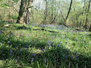
It's bluebell season! Usually that means a trip to Calke Abbey, but this time we decided to venture a little further afield. Shining Cliff Woods are just off the A6 between Belper and Cromford. They certainly lived up to their name on a surprisingly warm April day. The sunshine picked out startlingly green leaves, enthusiastic streams, and yes, the gorgeous colour of bluebells in bloom. 


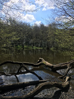
We had paused at a direction sign when some people came past and said, "Go that way, it's more interesting". That way took us up to a small reservoir, built to supply power to a wire works in the valley below. It had a No Swimming sign which I suspected many people ignore - it looked a perfect place for a wild dip. 


Further on, we passed a hostel and a fire circle tucked under a rocky outcrop. Graham had read about a 2000 year old yew tree at the other end of the wood, so we set out to find it. After a decent hike we found it - a broken stump, with two tiny yew saplings bravely carrying on the family line. Definitely not the enormous gnarled tree we had been expecting!

Theo and I by the stump

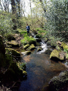
Fortunately the path back down the hill turned into a stream, which turned our walk into an exciting hop from rock to rock. The boys forgot their disappointment as they splashed their way down as fast as they could. 

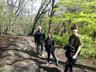
We came back through the derelict remains of the wireworks factory, which closed in 1996. This blog is worth a look if you like photos of deserted buildings - they obviously had a good time exploring the wireworks. Most of it is securely bricked up now, to prevent entry. So here's our attempt at a family selfie instead.


Comments

Popular posts from this blog

Trent Valley: Twyford, both ways

To complete my loop along the Dove Valley  from the mouth at Newton Solney up to Dovedale at Thorpe, across to Matlock on the Limestone Way , and back south along the Derwent Valley , I needed to walk one last section along the River Trent from Derwent Mouth to Repton. Originally I planned to do it in that direction. But for various reasons I ended up doing it the other way. The walk from Repton to Ingleby was completed weeks ago, at the beginning of June, and, for the sake of completeness, I also, later, walked from Findern to Twyford, on the other bank of the river. If I had done the walk sixty years or more ago, I could have crossed the river by ford or ferry at Twyford, and that would have been my most direct route home. the Trent at Twyford Walk 1: Repton to Ingleby Starting from the centre of Repton, I made my way out of the village and crossed the fields to Milton. Wystan Arboretum Milton The Trent Rivers Trust has been busy establishing the Trent Valley Way . This sect...

Trent Valley: the march of the pylons

In the 1980s, the River Trent supplied the cooling water for fifteen coal-fired power stations, each one gobbling up coal from the local mines and quenching its heat with gallons of river water. The area was known as Megawatt Valley . As the 20th century gave way to the 21st, the mines closed, the coal trains stopped running, and the iconic cooling towers, one by one, fell to the ground. The high-voltage electricity lines which connected the stations to the grid are still there, however, and they dominated the walk I did today. The stately silhouettes of pylons stalked across the landscape, carrying fizzing power lines which sliced up the sky. At one point, I was within view of two of the remaining sets of cooling towers. Diving further back into history, I parked by Swarkestone Lock on the Trent & Mersey Canal, walked past St James' Church, and arrived at Swarkestone Bridge, a 14th-century causeway which still, remarkably, carries traffic today. It was famously the southernmos...

The Churnet Way: a wonderful walk

The loop from Oakamoor to Froghall and back was one of the most enjoyable walks I've done in a long time. It had a bit of everything: woods, ponds, rivers and railways; steep climbs and sweeping views; an unusual church, an ex-industrial wharf, and, as a final bonus, car parks with toilets. Of course, the sunny weather helped too. I parked in Oakamoor and set off along a quiet lane called Stoney Dale. This is the route of the Churnet Way, which deviates away from the river for a couple of miles. After a while I turned right and climbed up through the woods on a gravelly path, then dropped down to the B5417. a spring in Oakamoor   Crossing the road, I entered Hawksmoor Nature Reserve. It has some fine gateposts commemorating John Richard Beech Masefield, "a great naturalist". I found a photo of the opening of the gateway in 1933; unsurprisingly, the trees have grown a lot since then! A track took me down through the woods to East Wall Farm. Lovely view! Nice duck pond as ...