The next section of the Derwent Valley Heritage Way took me from Duffield to the suburbs of Derby. It was a showery Saturday afternoon, so I went prepared with both waterproofs and sunhat.
I parked at the southern end of the walk, at Darley Abbey. There's a footpath that runs along the edge of Darley Park into the village.
 |
| gate to Darley Park |
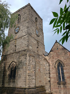
I soon came to St Matthew's Church, which was open. It had lovely large windows and some brightly painted woodwork in the tower. In one corner was the Millennium Window, celebrating the Light of God through 2000 years of history.
 |
| Millennium Window |
As soon as I left St Matthew's, it started raining. I sheltered under any trees I could find, but still got wet. The road took me towards Allestree, crossing the A38 at Palm Court Island. This is less tropical than it sounds. Round here, island is the word for a traffic roundabout, but the Palm Court Restaurant that gave this one its name is long gone.
 |
| Palm Court Island, A38 below |
The rain had stopped by the time I reached St Edmund's, Allestree, with its amazing Norman doorway. Inside, there was a splash of light illuminating a floral display. The rest of the church was in darkness.
Church Walk took me out to the A6. There was a milepost marking 2 miles to both Duffield and Derby. A former Methodist chapel (still a church) was to one side of it, and "Two Mile House" on the other side.
I veered off the main road to walk by the lake in Allestree Park. Some ducks took a keen interest when they discovered I had a sandwich with me.
The OS map marked a path that crossed the flood plain to Duffield Church. I was sceptical about whether it really existed, but there it was, with a sign and everything. Some of it was very overgrown, and of course all the vegetation was sopping wet. I was glad of my waterproof trousers.
The chimney of Peckwash Mill came into view across the River Derwent. When I got to the Derwent Valley Heritage Way, I knew I would be walking close to the chimney. But I had more flood plain to traverse on this side of the river first. I passed a random tumble of silage bales, said hello to a friendly sheep, and ducked underneath the railway.
This structure was clearly an embankment for a tramway leading to Peckwash Mill. It was interesting to see the layered structure.
And now I could see the spire of St Alkmund's, Duffield. Just a little further to the bridge, and the Bridge Inn. This is where I had left the DVHW last time.
On the eastern side of the Derwent, I started heading back to Darley Abbey. The path crossed some fields and then squeezed around the edge of what used to be Peckwash Mill. I always think of these as "reluctant" paths - where someone has grudgingly allowed just enough land to walk along.
I climbed up through some woods and came out at Little Eaton. By now it was almost 6pm, so I wasn't surprised that St Paul's Church was closed. I'm not sure it is regularly open, anyway. There seemed to be a village fete going on at the playing fields.
I walked through the village, passing a welcoming United Reformed Church, and followed a cycle path out to the A38.
There was a pedestrian crossing near the roundabout, but the Derwent Valley Heritage Way route suggested that I should follow a side road. The road led to a railway; I went up some steps to the A38 again; then, sure enough, there were steps down and an underpass.
On the other side of the underpass was a vast expanse of unfeasibly green grass. This was obviously being grown for turf. To one side, I could see where the dual carriageway crossed the Derwent. The spire of Breadsall church poked above the trees to my left. Despite busy roads all around, it felt peaceful.
At length I came out on the road to Darley Abbey Mills. The mill buildings have been redeveloped into restaurants and businesses. There is a little bridge over the river which used to be open to traffic, for a toll of £1 per car. It was condemned as unsafe a few years ago. Now it has an ugly structure built over the top of the original bridge, so that pedestrians and cyclists have a way to cross. I have a suspicion that this temporary fix will still be there in 20 years!
 |
| white building is old toll house |
Now I was almost back. Past a cricket match and up through Darley Park, and that was another walk done.


Comments